BART is a two track system. We were not built with extra tracks to provide redundancy and the ability to easily and quickly maneuver trains around delay incidents. We also have only one Transbay Tube with all lines converging in Oakland, easily creating a bottleneck. While infrequent, we from time to time experience something that prevents transbay service.
During these incidents we rely on our transit partners to get you where you need to go. Not everyone is an expert at knowing how to get across the bay without BART and without a car.
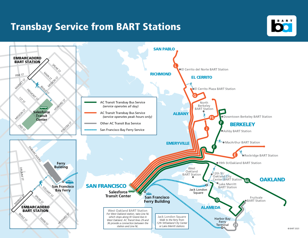
With that in mind, we’ve created this map which shows you transbay bus lines and ferry options located within walking distance to BART stations. The idea is to show you how to get as far as you can on BART and then where you can connect to a bus or ferry during these incidents. We also want to show a variety of pick up locations to avoid all riders trying to board a bus at the same stop.
Besides this map you can use the BART Trip Planner to find alternatives to BART to get where you need to go. The link automatically removes BART.

Download a PDF of this map to print out or save on your computer. (Tip: Save the image above to your phone so you can easily access it during a major BART disruption.)
Bookmark this page for quick reference: www.bart.gov/transbayalternatives
AC Transit Bus alternatives between BART stations
In the event of a BART disruption, use this information to plan your AC Transit trip between BART stations. Select the impacted BART station and see what your bus options are. www.actransit.org/BART-alternatives
Guaranteed and Emergency Ride Home Program
Several Bay Area counties provide a Guaranteed and Emergency Ride Home Program to offer eligible Bay Area residents the reassurance that you can get home in case of an emergency like illness, family crisis, or unforeseen overtime when you've taken an alternative mode of travel to work such as transit, a carpool, vanpool, or bike. Learn more about the program and if you qualify in your home county at https://511.org/carpool/guaranteed-ride-home